


FSWidgets QuickPlan

คำอธิบายของFSWidgets QuickPlan
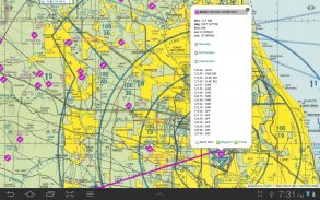
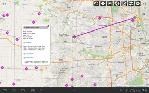
FSWidgets QuickPlan is a visual touch enabled flight planner that makes it easy to generate flight plans in native FSX, FS2004 or X-Plane formats.
For the folk commenting saying they didn't know it was a DEMO, we don't know how to make this any clearer. This is a DEMO only, the full version can be purchased from our site.
*** Please note, this is a DEMO VERSION ONLY ***
Demo is limited to the San Francisco (KSFO) region only, it is fully functional but will operate only in that region. For purchase details please visit our site and our store at http://fswidgets.com. We provide this demo to give you the opportunity to test QuickPlan and ensure you are happy with its features. Should you decide to purchase, you will receive a key that will unlock the demo version.
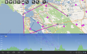
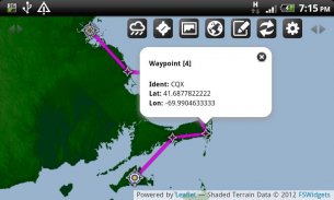
The entire route is generated visually, by tapping the map to add the departure airport, intermediate waypoints and arrival airport in the same order that you intend flying the plan.
Flight plans are saved and loaded using the SD card on the phone or tablet. Plans can be exported using any normal file browser on the Android device or by using standard Windows or Mac file management tools.
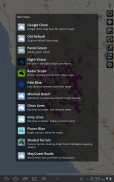
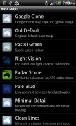
QuickPlan utilises a new mapping engine and includes 12 world-wide map styles and has support for FSWidgets Cloud Based Aero Chart products (free Cuba/Puerto Rico WAC Cloud Based Chart included) and the FSWidgets Cloud Based World Nav Data product (Free KSFO - San Francisco Bay area Nav Data included).
Main Features:
Supports tablets, hi-resolution phones, standard and low-end screens and devices
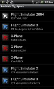
Generates native FSX (.pln), FS2004 (.pln) and X-Plane (.fms) format flight plans
Saves flight plans to the SD card, can be exported/imported
Flight plans can be exported via USB connection or SD card
Terrain profile display using the FSWidgets terrain engine
Search for airport by ICAO identifier
Map powered by CloudMade Leaflet API (using OpenStreetMap data)
Includes 14 world-wide maps styles
Supports FSWidgets Cloud Based Aero Charts
Free Cuba/Puerto Rico WAC Cloud Based Chart included
Supports FSWidgets Cloud Based World Nav Data
Free KSFO (San Francisco Bay) area Nav Data included
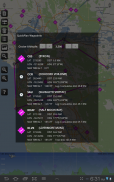
World-wide Metar and TAF Data icons
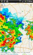
US Nexrad (Next-Gen Radar) Data
QuickPlan can be used in Freeform Mode, Advanced Mode, or a combination of both:
Freeform Mode:
Simply tap anywhere on the map and QuickPlan will allow you to add it as a generic waypoint. VFR pilots often use towns, lakes and other unique geographic features and with QuickPlan you can add any geographical location shown on the base map. Plans created this way label the waypoints automatically with generic names (e.g. DEP, WP1, WP2, ARR).
If desired, the entire route from departure to arrival can be created without reference to any navigational aids or official airports. This is handy for bush pilots who often use unlicensed airfields and small landing strips (or seaplane landing areas). Helicopter pilots can also quickly create plans that depart from off-airport locations like building rooftops or land on a road.
Advanced Mode:
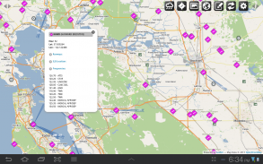
If you own the FSWidgets Cloud Based World Nav Data product you can create more advanced flight plans by tapping on any of the icons displayed on the map to add them as waypoints - airports, VOR's, NDB's and intersections (data for the KSFO area is included free). Plans created this way label the waypoints automatically with airport and navigational aid identifiers taken from the Nav Data (e.g. KSFO, OSI, LV, FABLA).
Who we are:
FSWidgets is a software development team based in Australia, specializing in add-ons for Microsoft Flight Simulator (Windows) and Laminar Research X-Plane (Windows, Mac, Linux). Both of its founding members have extensive experience in creating award-winning add-ons for flight simulators and have been active in the simming community for well over a decade.
</div> <div jsname="WJz9Hc" style="display:none">FSWidgets QuickPlan เป็นสัมผัสที่ภาพการวางแผนการบินเปิดการใช้งานที่ทำให้มันง่ายในการสร้างแผนการบินใน FSX, FS2004 หรือ X-Plane รูปแบบพื้นเมือง
สำหรับชาวบ้านแสดงความคิดเห็นว่าพวกเขาไม่ได้รู้ว่ามันเป็น DEMO ที่เราไม่ทราบวิธีที่จะทำให้เรื่องนี้ใด ๆ ที่ชัดเจน นี้เป็นเพียงการสาธิตรุ่นเต็มสามารถซื้อได้จากเว็บไซต์ของเรา
*** โปรดทราบนี้เป็นรุ่นสาธิต *** เท่านั้น
การสาธิตจะถูก จำกัด พื้นที่ซานฟรานซิ (KSFO) เท่านั้นมันจะทำงานอย่างเต็มที่ แต่จะดำเนินการเฉพาะในภูมิภาคที่ สำหรับรายละเอียดการซื้อกรุณาเยี่ยมชมเว็บไซต์ของเราและร้านค้าของเราได้ที่ http://fswidgets.com เราให้บริการการสาธิตนี้เพื่อให้คุณมีโอกาสที่จะทดสอบ QuickPlan และให้แน่ใจว่าคุณมีความสุขกับคุณลักษณะของมัน หากคุณตัดสินใจที่จะซื้อคุณจะได้รับที่สำคัญที่จะปลดล็อครุ่นสาธิต
ตลอดเส้นทางจะถูกสร้างขึ้นสายตาโดยแตะแผนที่เพื่อเพิ่มสนามบินต้นทางจุดกลางและสนามบินมาถึงอยู่ในลำดับเดียวกับที่คุณตั้งใจบินแผน
แผนการบินจะถูกบันทึกและเรียกใช้ SD การ์ดในโทรศัพท์หรือแท็บเล็ แผนสามารถส่งออกโดยใช้เบราว์เซอร์ไฟล์ใด ๆ ปกติบนอุปกรณ์หรือโดยใช้มาตรฐาน Windows หรือ Mac เครื่องมือในการจัดการไฟล์
QuickPlan ใช้เครื่องมือการทำแผนที่ใหม่และ 12 รวมถึงรูปแบบแผนที่ทั่วโลกและมีการสนับสนุน FSWidgets เมฆจาก Aero ผลิตภัณฑ์แผนภูมิ (ฟรีแผนภูมิคิวบา / เปอร์โตริโก WAC เมฆตามรวม) และผลิตภัณฑ์ FSWidgets เมฆจากโลก Nav ข้อมูล (ฟรี KSFO - ซาน พื้นที่ Francisco Bay Nav ข้อมูลรวม)
คุณสมบัติหลัก:
รองรับเม็ด, โทรศัพท์ความละเอียดสูงหน้าจอมาตรฐานและต่ำสุดและอุปกรณ์
สร้างพื้นเมือง FSX (. pln) FS2004 (. pln) และ X-Plane แผน (. FMS) รูปแบบการบิน
บันทึกแผนการบินไปที่ SD card ที่สามารถส่งออก / นำเข้า
แผนการบินจะสามารถส่งออกผ่านการเชื่อมต่อ USB หรือ SD การ์ด
แสดงรายละเอียดภูมิประเทศโดยใช้เครื่องยนต์ภูมิประเทศ FSWidgets
ค้นหาสนามบินโดยเคาระบุ
แผนที่ขับเคลื่อนโดยแผ่นพับ CloudMade API (ใช้ข้อมูล OpenStreetMap)
รวม 14 รูปแบบแผนที่ทั่วโลก
รองรับแผนภูมิ FSWidgets เมฆจาก Aero
แผนภูมิฟรีคิวบา / เปอร์โตริโก WAC เมฆอยู่รวม
รองรับ FSWidgets เมฆจากโลก Nav ข้อมูล
พื้นที่ฟรี KSFO (San Francisco Bay) Nav ข้อมูลรวม
ไอคอน Metar และ TAF ข้อมูลทั่วโลก
สหรัฐอเมริกา NEXRAD (Next-Gen เรดาร์) ข้อมูล
QuickPlan สามารถใช้ในรูปแบบอิสระโหมดขั้นสูงหรือการรวมกันของทั้งสอง:
โหมดรูปแบบอิสระ:
เพียงแค่แตะที่ใดก็ได้บนแผนที่และ QuickPlan จะช่วยให้คุณสามารถเพิ่มเป็น waypoint ทั่วไป นักบิน VFR มักจะใช้เมืองทะเลสาบและคุณสมบัติอื่น ๆ ทางภูมิศาสตร์ที่ไม่ซ้ำกันและมี QuickPlan คุณสามารถเพิ่มที่ตั้งทางภูมิศาสตร์ใด ๆ ที่แสดงบนแผนที่ฐาน แผนการสร้างด้วยวิธีนี้ป้ายจุดโดยอัตโนมัติด้วยชื่อทั่วไป (เช่น DEP, WP1, WP2, ARR)
ถ้าต้องการให้เส้นทางทั้งหมดจากการเดินทางที่จะมาถึงสามารถสร้างขึ้นได้โดยไม่มีการอ้างอิงที่จะช่วยการเดินเรือใด ๆ หรือสนามบินอย่างเป็นทางการ นี้จะมีประโยชน์สำหรับนักบินพุ่มไม้ที่มักจะใช้สนามบินที่ไม่มีใบอนุญาตและแถบเชื่อมโยงไปถึงเล็ก (หรือพื้นที่เชื่อมโยงไปถึงเครื่องบิน) นักบินเฮลิคอปเตอร์ยังสามารถได้อย่างรวดเร็วสร้างแผนการที่ออกจากสถานที่ปิดสนามบินเช่นหลังคาอาคารหรือที่ดินบนถนน
โหมดขั้นสูง
หากคุณเป็นเจ้าของผลิตภัณฑ์ FSWidgets เมฆจากโลก Nav ข้อมูลที่คุณสามารถสร้างแผนการบินที่สูงขึ้นโดยการแตะที่ไอคอนที่แสดงบนแผนที่เพื่อเพิ่มพวกเขาเป็นจุด - สนามบิน, วัวของ NDB และทางแยก (ข้อมูลสำหรับพื้นที่ KSFO รวม ฟรี) แผนการสร้างด้วยวิธีนี้ป้ายจุดโดยอัตโนมัติกับสนามบินและเครื่องช่วยการเดินเรือระบุนำมาจาก Nav ข้อมูล (เช่น KSFO, OSI, LV, FABLA)
ที่เรา:
FSWidgets เป็นทีมพัฒนาซอฟต์แวร์ในประเทศออสเตรเลียมีความเชี่ยวชาญใน add-on สำหรับ Microsoft Flight Simulator (Windows) และลามิวิจัย X-Plane (Windows, Mac, Linux) ทั้งสองสมาชิกผู้ก่อตั้งของมีประสบการณ์ในการสร้างที่ได้รับรางวัลส่วนเพิ่มในการจำลองการบินและได้รับการใช้งานในชุมชน simming ดีกว่าทศวรรษ</div> <div class="show-more-end">
FSWidgets QuickPlan--เวอร์ชั่น2.2 - Jan 24, 2015
(08-02-2015)
FSWidgets QuickPlan - ข้อมูล APK
เวอร์ชั่น APK: 2.2 - Jan 24, 2015แพ็คเกจ: com.fswidgets.quickplanเวอร์ชั่นล่าสุดของFSWidgets QuickPlan
เวอร์ชั่นอื่น


แอปในประเภทเดียวกัน


